Public sector/Government decision-making units

Agricultural Understanding platform
Fields are the atomic units of agriculture. Generating agricultural insights at an individual field level is critical to a meaningful change in the agri ecosystem.

Diversity of landscape and crops lead to very different requirements between two fields in proximity to each other

Currently, insights are available at an aggregate level, but the intervention and advisory is needed at an individual or farm level

Leveraging high resolution satellite imagery, Google Maps corpus and bespoke ML models

Agriculture Landscape Understanding
(Preview)
Landscape understanding leverages satellite imagery and machine learning to draw agricultural boundaries of fields, the basic unit of agriculture and essential in creating meaningful insights. With field segments established, the model can determine the acreage of farm fields. Similarly other landscape elements like water bodies and vegetation can be identified, which can help with drought contingency planning.
Read our Research paper

Agricultural Monitoring and Event Detection
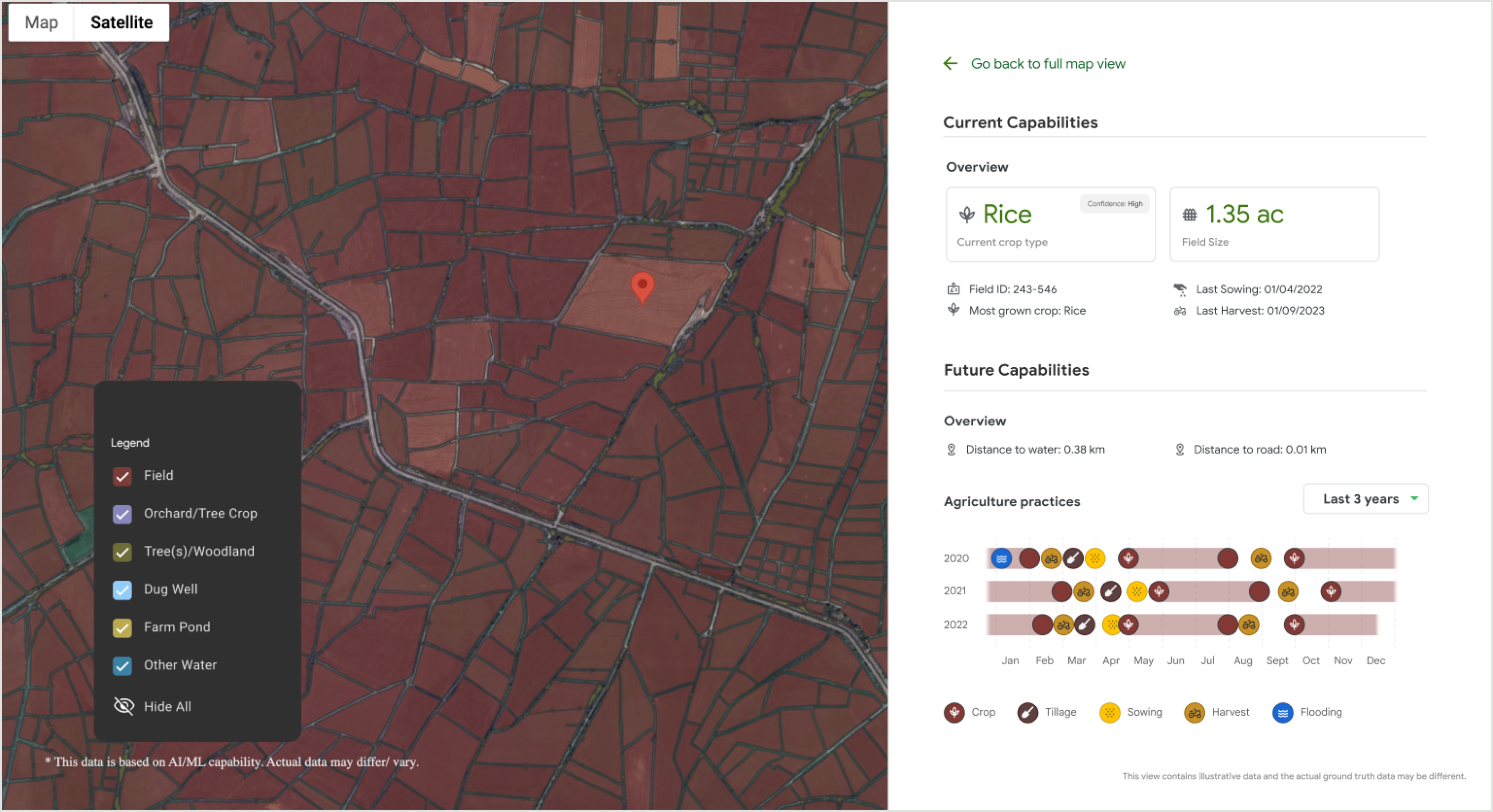
For the identified agricultural fields, via AMED API we provide historical and current in-season crop monitoring. AMED builds on ALU, and can be queried the same way ALU is. Predicted data is organized at field level in chronologically ordered crop seasons containing the predicted crop labels.
Read our Research paper
ALU is now available in Google Earth
Use these granular insights to:


Calculate specific acreage

Identify water resources for drought contingency planning

Deliver insights at the farm level, not just the regional level
Agricultural Landscape Understanding is coming to BigQuery

The dataset can be used for a number of use cases including:

Agritech enterprises for Digital services and agronomic advice


Organizations focused on carbon offsets

Financial institutions for Assessment of credit-worthiness of farmers
Public sector/Government decision-making units

Organizations focused on carbon offsets
Agritech enterprises for Digital services and agronomic advice
Financial institutions for Assessment of credit-worthiness of farmers
Our foundational models are now available more broadly in the Global South


Our Partners
Partnerships with state governments, academic institutions and agritech enterprises


Rama Devi Lanka
Director-Emerging Technologies ITE&C Department | Government of Telangana
"We are excited to collaborate with Google Research to leverage their satellite-based field segmentation and crop classification data models. This collaboration will help us co-create advanced, data-driven solutions that will help leapfrog the digital journey of the agri-ecosystem in India.”
Read full testimony

Sibi Prabhakaran
CEO’s Office @ Ninjacart
“I commend Google for their exemplary innovation in AI to empower farmers and strengthen agriculture. By leveraging Google's ALU model outputs to extract field boundaries with precision, we have greatly enhanced crop booking and farm advisory features in our mobile app serving the Department of Agriculture, Government of Telangana. “
Read full testimony

Krishna Chaithanya
Founder & CEO at Team-Up!
“Google's AnthroKrishi has revolutionized the way we perceive and manage farm boundaries. The automated and accurate farm boundary detection platform has proven to be a cost-effective and precise solution for farm boundary delineation, presenting a significant advancement for the agriculture industry.”
Read full testimony

Yogesh Patil
CEO at Skymet
“IIT Bombay has been interacting with the ALU team for more than a year now and has seen the ALU output as it has evolved. Our interest has been to deploy it to various development sectors related to agriculture. The ALU serves as an extremely useful proxy for ground reality.”
Read full testimony

Milind Sohoni
Teacher at Indian Institute of Technology, Bombay
Rama Devi Lanka
Director-Emerging Technologies ITE&C Department | Government of Telangana
Sibi Prabhakaran
CEO’s Office @ Ninjacart
Krishna Chaithanya
Founder & CEO at Team-Up!
Yogesh Patil
CEO at Skymet
Milind Sohoni
Teacher at Indian Institute of Technology, Bombay